Chris Lavers: Space-Based Monitoring of Armed Conflict and its Impact on Civilians
Resource type: Blogs
Chris Lavers a Visiting Research Fellow at the CCW during the 2020-2021 academic year, christopher.lavers@plymouth.ac.uk
This article explores the existing use of satellite imaging for the monitoring of armed conflict impact, including settlement distractions and environment deterioration. In combination with the “traditional” data, satellite imaging might play a crucial role in the protection of civilians and providing evidence of human rights violations.
High resolution commercially available satellite imagery is one of several maturing technologies which can provide near real-time monitoring of a wide range of activities including remote surveillance of at-risk groups, man-made land use and land cover activities. It is expected economic globalisation and climate change-related pressures will increase the frequency and severity of regional conflicts over resources (Mabey, 2008). My research looks at the impact of armed conflict on civilians, in the context of environment and resources, documenting and providing baseline data to help mitigate civilian suffering (Lavers, 2008). Satellite imagery provides the ability to monitor isolated regions and embedded groups of civilians at risk of exploitation including from armed factions. High resolution satellite imagery for human rights was proposed during Bosnia’s ethnic conflict (Willum, 1999) but it is in the last decade imagery of sufficiently high resolution has become available for practical humanitarian and environmental applications.
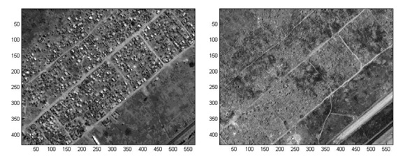
GeoEye, Digital Globe, and British company Earth-i, provide metric, sub-metric, and near real-time persistent space-based video for earth observation with Ikonos 2, Quickbird 2, and VividX2 (weighing just 100 kg) satellites, such that commercial imaging is available for GIS-related applications. Multispectral imaging typically provides colour and NIR data to characterise urban, rural areas, and land management. This generation of commercial providers, and declassified military imagery, is ideal for ‘swords into ploughshares’ applications using technology previously only found in the military domain. Influenced by geopolitical and ideological shifts, the global and local security landscape is changing rapidly in many armed conflicts. Satellite imaging may be the means for monitoring and mitigating dynamic armed conflicts by providing quantitative and qualitative data (figure 1).
A vital challenge for abuse allegations on civilians within armed conflict is rapid response to reports (perishable information), often imprecisely located, and gathered under difficult conditions. Lack of information on affected area size, distribution, and numbers hinders effective timely response by the international community in order to mitigate or prevent further harm to civilians. Situations are complicated by governments’ unwilling to allow NGO’s, and others, access to verify conditions or provide humanitarian relief. From a monitoring perspective, prevention is better and less costly than cure. Using high resolution satellite archives to supplement other verifiable data, e.g. eye-witness reports, helicopter, and increasingly UAV flights provides vital NGO ground tools to assess dwelling and population change, and detailed maps for key resource access and management: water, shelter, food etc.
Combining Satellite Images with Other Data
Conflict visualisation of temporal and spatial relationships to identify ‘patterns of life’ and appropriate response is critical. The use of satellite imagery to comprehend complex regional armed conflict, combining traditional methods with digital data provides new ways to record and analyse conflict, and its consequences, and is relevant to all armed conflicts. Aircraft or UAVs may take post-disaster conflict images, but data collection is often expensive and time-consuming, reliant on government permission. Flights over conflict zones can place staff in unnecessary danger, especially if local forces intend to hide their operations. Sometimes satellite imagery is the only recourse as NGOs are ‘barred’ from areas and press access is limited.
High resolution satellite imagery can corroborate reports gathered by those working in the field. Eye-witness reports are checked where available against satellite imagery for known latitude and longitude. Typical image characteristics are noted: village’s structure removal, burn scars, relocated or cleared villages, military camp expansion, agricultural abandonment, or people relocated into camps, often across borders. Villages and structures may be removed by bulldozing, and military compounds added. Removal and abandonment cause may not always be attributed to structural removal, but systematic burning is compelling hostile evidence when combined with verbal ground reports. Key features of ‘before and after’ imagery allow changes, e.g. burnt villages, to be identified. However, there isn’t always a high resolution ‘before’ image, and acquisition may be problematic if conditions are cloudy or dark, but the comparison of imagery, in reported areas, can be tested.
Examples of the Successful Use
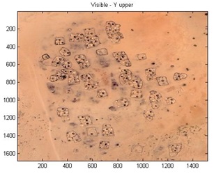
Having collaborated with HART, aid and advocacy organisation, which supports health clinics and medical facilities for the vulnerable in rural Uganda, Nigeria, East Timor, and Armenia, we targeted and identified from satellite imagery key areas to avoid danger and likely attack. In that project, we accessed with permission, Amnesty International’s satellite monitoring of vulnerable Darfur villages (www.eyesondarfur.org website now inaccessible). Their web-site represented a bold new human rights approach, putting Sudanese ex-President Bashar’s government on notice their actions were being monitored abroad. For example, Donkey Dereis in Darfur, which had hundreds of huts in 2004, but by 2006 it was a landscape overrun with burn-scarred vegetation as depicted in figure 2 (Lavers, 2008).
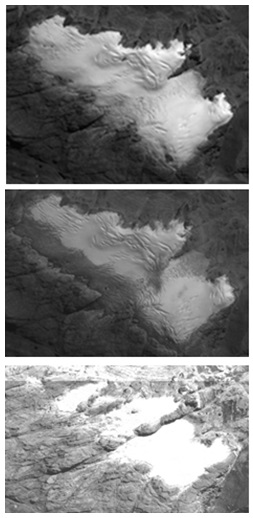
The Great Lakes region and Sudan are rich in various natural resources which may drive and sustain conflicts. There are several ways satellite imagery can provide ‘metrics’ on the scale of resource trade, environmental damage, and life impacts, e.g. water access. Territory and resources have long been key motivations for war and activities falling short of conflict by state and non-state actors. We investigated West Papuan mineral exploitation (Lavers, 2010), and Indian mining impact on isolated Dongriah Kondh tribes (Lavers, 2010), to mitigate unlawful and environmentally damaging activities, which unaddressed may lead to insurgency as the remaining option to address grievances, exacerbated by harsh geography and worsening climate, combined with diminishing glacial resources in figure 3 (Sara, 2020).
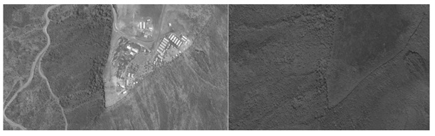
Water issues are common, e.g. damming of the Ethiopian Omo, which impacted indigenous pastoralists with security camp building (figure 4).
In the presence of increasing population, resource scarcity, climate-change pressures, ethnic rivalries, and religious conflict the importance of time and location stamped image verification will become more important in armed conflicts where NGOs or international observers access is limited due to difficult terrain, or security restrictions imposed by governments or non-state actors.
References:
Bromley, L, High-Resolution Satellite Imagery and the Conflict in Eastern Burma, AAAS, Science and Human Rights Program, 2007.
Checchi, F, et.al., Estimates of crisis-attributable mortality in South Sudan, December 2013-April 2018:A statistical analysis, LSHTM, September 2018.
Lavers, CR, et.al., Application of satellite imagery to monitoring Human Rights abuse of vulnerable communities, with minimal risk to relief staff. Journal of Physics Conference Series, July 2007, 178(1):012039 DOI: 10.1088/1742-6596/178/1/012039X
Lavers, CR, et.al., Application of high-resolution satellite imagery to environmental assessment of mining impact in West Papua. (2010) RSPSOC conference proceedings.
Lavers, CR, High resolution Satellite imagery in mining applications and human rights, Planet Earth magazine, 2010.
Lavers, CR, Application of high-resolution IKONOS satellite imagery to human rights monitoring of land clearances and Internally Displaced People population evaluation studies, and affects upon Grasberg communities. Session #12 Remote Sensing, Imaging and Lidars OASIS 3, Israel. 2011.
Lavers, CR, et.al., Ikonos Satellite imagery for NDVI related assessment applied to land clearance studies, Proc. SPIE 11534, Earth Resources and Environmental Remote Sensing/GIS Applications XI, 1153417; doi: 10.1117/12.2584921 Event: SPIE Remote Sensing, 2020.
Mabey, N, Delivering Climate Security International Security Responses to a Climate Changed World, Whitehall Paper 69, RUSI, 2008.
Willum, B, Human Rights Abuses Monitored with Satellite Imagery: Myth or Reality? Master of Arts in War Studies Kings College London, September 1999.